The GPS is same satellite navigation component that determines your precise location on the Earth. Once your location is detected, it is displayed as a set of longitude and latitude coordinates. A chartplotter is an electronic map of either the coastal waters, inland lakes, or any other navigable waters around the world. The GPS chartplotter we are all most familiar with is the one that sits on the dashboard of our car. We simply input our destination, and the GPS chartplotter (more commonly referred to as only a GPS) plots our course along the roads and tells us when, and which way to turn so we don't get lost. So although you can get a GPS unit without a chartplotter (you can either map your coordinates by hand on a paper map, or input your GPS data to a laptop via specialized software) a chartplotter cannot operate without a GPS unit. So how does this benefit me when I'm out fishing?
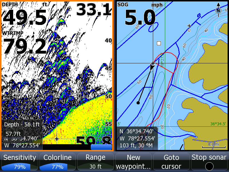
The main benefit of a GPS chartplotter is its ability to mark your location. This electronically fixed location is called a waypoint. Without realizing it, we have all been using waypoints from the very first time we decided to walk or drive somewhere and needed directions. The directions would not only include street names and distances, but also landmarks to look out for. These landmarks are the same as waypoints.
Unfortunately, there are not may stationary reference points on the open water. When fishing in smaller rivers and streams it's relatively easy to remember the bend one hundred yards before the waterfall across from the largest oak tree. That's not so easy when you're 10 miles off shore in Lake Michigan. Fortunately, your GPS chartplotter will electronically mark your location and allow you to label it for easier identification later on. After all, what's the use of having 50 electronically stored locations if you don't know which one was where you caught all those steelhead, trout, perch or walleye, last year. Depending on the time of year, you can pick your spot, and return to exactly the same location every time. Naturally, this doesn't guarantee the fish will still be there, but you now know where to start looking.
Another benefit of GPS chartplotters is that many of them have microSD card slots where you can input maps of different waterways and regions, such as the coastal US, Great Lakes, and inland lakes. Not only are these basic navigational charts available, but more advanced models will have options to connect to the manufacturer's marine/navigation network which provides the most up to date information on water conditions, buoy locations, shallows, and submerged hazards to name a few. Using this composite information, your chartplotter will provide you with the safest route either out to your desired location, or back safely to port.
So whether you're a seasoned captain or a newly licensed recreational boater, a GPS chartplotter can make your time on the water safer and easier to navigate. Remember, out on the open water, you can't pull over to the nearest gas station and ask for directions. Your charplotter, with stored waypoints and saved routes will show you how to get exactly where you want to go.
If fishing is your passion, or you just like spending a relaxing day out on the open water, why not get a GPS chartplotter and set a course for safety. You can find lots of information on different brands of GPS Chartplotters right here, including Humminbird, Northstar, Garmin and Lowrance. You'll find detailed information on their different features and options, and also links purchase the one that suits your needs.
Article Source: http://EzineArticles.com/?expert=Mark_Rocco
See my previous post: The Benefits of Fishing With Homemade Lures
See my previous post: The Benefits of Fishing With Homemade Lures


{ 0 comments... read them below or add one }
Post a Comment